Florence becomes a hurricane as it barrels toward the U.S.
- Share via
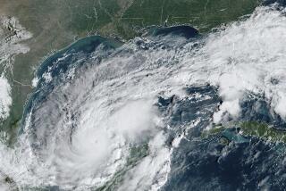
Reporting from Baltimore — Tropical Storm Florence morphed into a hurricane Sunday and swirled toward the U.S. for what forecasters said could be a direct hit on the Southeast toward the end of the week.
The storm’s sustained winds reached 75 mph, just over the threshold for a hurricane, as it made its way across the Atlantic, about 750 miles southeast of Bermuda, the National Hurricane Center said. It was moving west at 6 mph.
The Miami-based center said that it was still too early to predict the hurricane’s exact path but that a huge coastal area from South Carolina to the mid-Atlantic region should prepare for a major strike late in the week.
“All indications are that Florence will be an extremely dangerous Category 4 hurricane while it moves over the western Atlantic toward the southeastern United States,” the hurricane center said. A Category 4 storm packs winds of 130 mph or more and has the potential for catastrophic damage.
Meteorologists urged residents to “closely monitor the progress of Florence, ensure they have their hurricane plan in place and follow any advice given by local officials.”
After a couple of days as a tropical storm, Florence regained hurricane status by late Sunday morning and was expected to rapidly intensify early Monday, becoming a major storm with sustained winds of at least 110 mph.
The possibility that the storm will make a turn to miss the coast appeared to be all but gone Sunday.
The hurricane center’s latest forecast cone for the storm projects it will make landfall Thursday night or early Friday morning as a Category 4 hurricane near the North Carolina-South Carolina border.
Maryland Gov. Larry Hogan advised his state’s residents to be prepared for the storm, and the governors of South Carolina, North Carolina and Virginia declared states of emergency. Residents of those states were urged to begin securing their homes and properties this weekend, and cruise lines had already begun to redirect their ships to avoid the path of Florence as it begins to bear down on the United States.
“There’s still a cone of uncertainty over as to how this storm will develop,” said Brian Lasorsa, a meteorologist with the National Weather Service. “It could slow down or change track.
“But anyone living on the East Coast should place close attention in the next few days to where this storm goes and what it does. If I was living on the East Coast, I would start making plans now in case I had to go somewhere fast.”
Even if Florence remains entirely at sea, the storm is likely to generate heavy seas and hazardous rip currents along the U.S. this weekend, the hurricane center warned.
The storm’s effects were already being felt along the coast. Assateague State Park closed its beaches until further notice Sunday amid 12-foot waves and surging tides.
National HC
The National Weather Center warned of dangerous rip currents in popular tourist areas like Virginia Beach and the Outer Banks. Advisories warning of dangerous beach conditions or coastal flooding were in effect for parts of New Jersey, Delaware, Virginia, North Carolina, South Carolina, Georgia and Florida.
McCauley and Dance write for the Baltimore Sun.
The Associated Press contributed to this report.
UPDATES:
4:26 p.m.: This article was updated with staff reports.
This article was originally published at 12:10 p.m.
More to Read
Sign up for Essential California
The most important California stories and recommendations in your inbox every morning.
You may occasionally receive promotional content from the Los Angeles Times.


