Worst of SoCal rainstorm set to hit Sunday and Monday. What you need to know

- Share via
The worst of the first significant rainstorm of the season for Southern California is expected to hit Sunday and Monday. Here is what you need to know:
Timing
Forecasters with the weather service issued a flood watch for the burned areas of the recent L.A. County fires for the time period of highest risk — from 10 a.m. Sunday through 4 p.m. Monday.
By 3 p.m. Sunday, a handful of locations in western Los Angeles County had received half an inch of rain, according to the weather service. Downtown Los Angeles received .32 inches of rain. There were also reports of streets flooding in the L.A. area due to clogged drains.
“We still have some showers coming up from the south,” said Carol Smith, a meteorologist with the National Weather Service. “More is on the way.”
Sunday night will be the period of particularly high concern, officials said.
L.A.’s first significant storm of the season has already forced the closure of the 5 freeway at the Grapevine, unleashed mud on roadways, and triggered school closures in Malibu.
This is “a slow moving storm, so it’s going to be stubborn. It’s going to hang around,” said Alex Tardy, meteorologist with the National Weather Service office in San Diego. “It’s going to send waves of moisture through Monday. So I think that’s really going to add up to significant rain and snow.”
Forecast
The mountains of Los Angeles and Ventura counties could get 2 to 3 inches of rain, while half an inch to 1 inch is possible elsewhere.
Through Monday, Covina could get 1.32 inches of rain; downtown L.A., 1.14 inches; Long Beach, 1.12 inches; Canoga Park, 1.05 inches; Santa Clarita, 1.04 inches; Fillmore, 1.02 inches; Redondo Beach, 0.95 inches; and Thousand Oaks, 0.87 inches.
If the storm produces rain on the higher end of estimates, from 1 to 1.5 inches of rain could fall in Orange County, Ontario, Riverside, Lake Elsinore, Temecula and coastal northern San Diego County. From 0.7 to 1 inch of rain could fall in San Diego, and from 1.5 to 2 inches in San Bernardino.
This article is provided free of charge to help keep our community safe and supported during these devastating fires.
Flood concerns in burn area
A flood watch is issued when weather conditions are favorable for flooding. “It does not mean flooding will occur, but it is possible,” the weather service says.
Part of Pacific Coast Highway was closed Sunday afternoon due to flooding in Topanga Canyon, according to meteorologist Joe Sirard, of the National Weather Service’s office in Oxnard. A rain gauge picked up 0.74 inches on Topanga Canyon Boulevard on the edge of the fire boundary, he said.
L.A.’s first significant storm of the season has already forced the closure of the 5 freeway at the Grapevine, unleashed mud on roadways, and triggered school closures in Malibu.
Forecasters have increased their projections of how much rain could fall. The adjusted forecast is a result of the low pressure system, dropping in from Canada, appearing to veer a little bit more to the west — a little bit more off the coast of Southern California — than initially expected, which would make this storm wetter.
That’s resulting in the “increased concerns for debris flows over some of the burned scars,” Kittell said.
Still, considerable uncertainty remained Saturday afternoon, with outcomes dependent on the storm’s precise path and speed, said Kristan Lund, meteorologist with the National Weather Service in Oxnard.
If the low pressure system wobbles a bit west toward the water, it will pick up more moisture and result in higher rainfall totals, while a more inland route to the east will mean less rain, she said. And if the storm ends up being a little slower than expected, it could sit over one area and prolong rainfall there, or result in heavier rainfall across the board, she said.
“These patterns tend to be a little more unpredictable in terms of you really don’t know until it arrives what it’s going to end up doing,” she said.
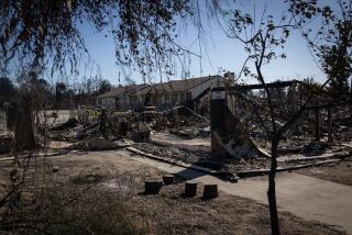
Forecasters said there is now a 10% to 20% chance of significant flash flooding and debris flow capable of damaging roads and homes in the most vulnerable recently burned areas, namely, the areas of the Palisades and Franklin fires around Pacific Palisades and Malibu, the Eaton fire around Altadena and Pasadena, the Hughes fire around Lake Castaic, and the Bridge fire in the Angeles National Forest north of Glendora.
Preparation
Among the weather service’s recommendations: Avoid recently burned areas during that period. Use sandbags to protect property. And residents who do decide to stay can “stock up on supplies in case road access is blocked.”
Context
The rain is expected to snap a record, or near-record, streak of dry weather for Southern California. Most areas of the region have received less than 5% of the average accumulated rainfall for this point in the water year, which began Oct. 1.
Until late Saturday, Downtown Los Angeles had received just 0.16 of an inch of rain since Oct. 1, which is just 2% of the average at this point in the water year — 6.48 inches. Downtown L.A.’s annual average rainfall is 14.25 inches.
On Saturday night, 0.11 of an inch of rain fell on downtown L.A.
Southern California is now either in “extreme drought” or “severe drought,” according to the U.S. Drought Monitor.
More to Read
Sign up for Essential California
The most important California stories and recommendations in your inbox every morning.
You may occasionally receive promotional content from the Los Angeles Times.


