Two destructive fires. Hundreds of miles apart. One culprit: Winds

- Share via
SAN FRANCISCO — The two fires broke out hours apart and hundreds of miles from each other.
But the fire that burned into subdivisions in suburban Santa Clarita Valley and the blaze that tore though bucolic Northern California wine country had one thing in common: fierce winds.
In Sonoma County, the Kincade fire was fueled by Diablo wind gusts that topped 70 mph. In Santa Clarita, the Santa Ana wind gusts were slightly less powerful but came with very low humidity and temperatures that hit the 90s.
In each case, the winds made the fire all but impossible to stop.

What are Diablo winds, and how are they different from the normal weather pattern for the Bay Area?
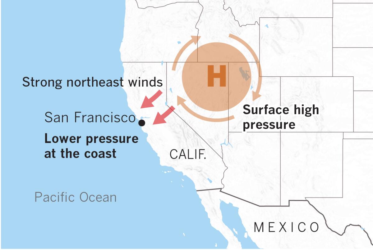
The normal weather pattern near the coast is for moist sea breezes to come off the Pacific Ocean and travel inland. But in the fall, high pressure that builds over the Great Basin in Nevada and Utah causes wind to shift in the opposite direction, according to Jan Null, an adjunct professor of meteorology at San Jose State University and a former meteorologist with the National Weather Service.
In Northern California, they’re called Diablo winds; in much of Southern California, they’re called Santa Ana winds. Similar winds that threaten Santa Barbara are called sundowner winds. In the Sacramento Valley area, Jarbo Gap winds are what locals call the gusts that howl through the Feather River Canyon as high-pressure air over Nevada and Utah seeks a path through the state’s mightiest mountain range, the Sierra Nevada, to fill the lower-pressure voids on the California coast.
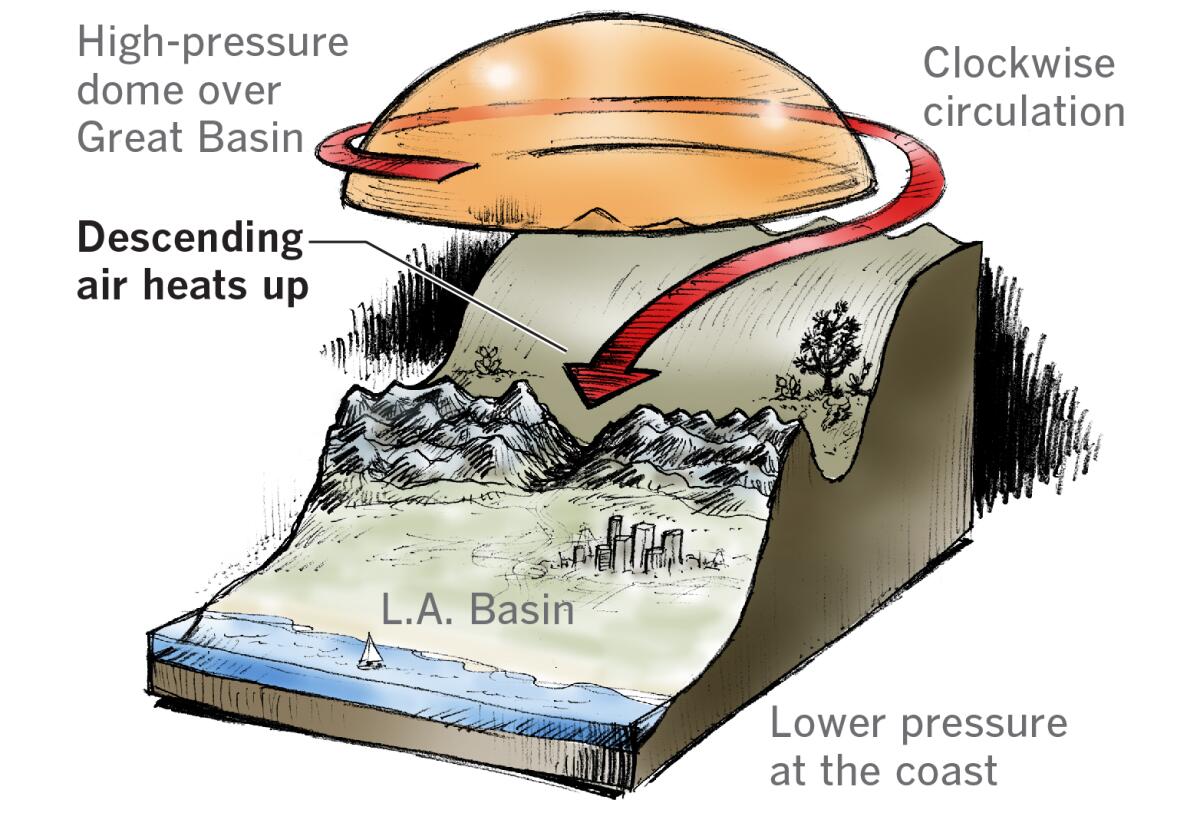
In Northern California, the winds arrive when air coming down from Nevada and Utah, falling from an elevation of about 4,000 feet, gets pushed down to sea level. That air is compressed, and warm winds are created.
What are examples of how Diablo and Santa Ana winds have fueled fast-moving wildfires?
A classic example of a destructive fire fueled by Diablo winds is the October 1991 firestorm that struck the Oakland and Berkeley hills, killing 25 people and destroying about 2,900 structures. Until 2017, that fire was the most destructive in California history.
Two more fires have been more destructive since then.
PHOTOS: Kincade and Tick fires in Sonoma County and Santa Clarita area
The Tubbs fire of Sonoma and Napa counties in October 2017 roared 12 miles in four hours into Santa Rosa, killing 22 people and eventually destroying more than 5,000 structures.
The Camp fire of Butte County, which destroyed much of the town of Paradise and destroyed more than 18,000 structures last November, is now the state’s most destructive fire on record. A Los Angeles Times analysis published last year said the fire grew at a rapid clip — about 4,600 acres an hour — a rate that was matched by the Tubbs fire and other California fires. The Camp fire led to more than 80 deaths.
California’s fourth most destructive fire, the Cedar fire of San Diego in 2003, grew even faster than the Camp fire. That fire had kindled for hours until a Santa Ana wind rolled in at midnight. By 3 a.m., the wind-driven fire had jumped a river and a reservoir and run nearly 17 miles. In the three-hour run, the fire spread an average of more than 19,600 acres an hour. Fifteen people were killed and more than 2,800 structures destroyed.
The same high-pressure, low-pressure gradient last year set up a Santa Ana wind event that pushed the Woolsey fire into Malibu. Its pace in the first three hours was 21,290 acres an hour. It destroyed more than 1,600 structures and caused three deaths.

What is the origin of these Diablo winds?
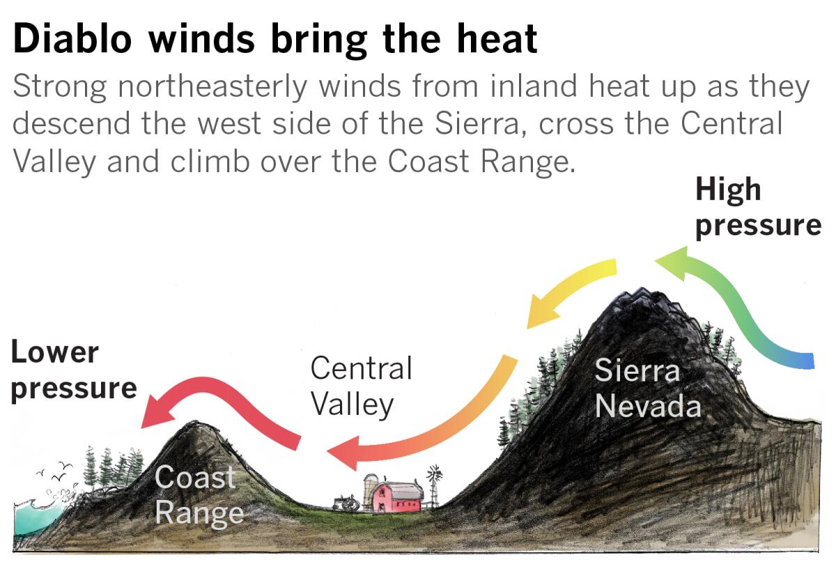
They originate hundreds of miles inland in the desert regions of the Great Basin. There, circulation around a strong area of surface high pressure flows over the Sierra Nevada, heading toward lower pressure at sea level.
The air rushing over the peaks and down the western mountain slopes heats up from compression, dries out and speeds up as it is forced through narrow canyons and passes.
As it crosses the Central Valley, the air dries out more, then it lifts up and over the Coast Range. That gives it a second round of compression heating as it funnels down the western coastal slopes toward the Pacific Ocean.
What are the conditions going forward?
A second round of extreme fire weather will return to Northern California on Saturday, with gusts as high as 80 mph possible this weekend in the North Bay and East Bay hills at elevations above 1,000 feet. The wind conditions will be worse than experienced Thursday morning.
In Southern California, the Santa Ana winds are expected to continue through at least Friday.
Lin reported from San Francisco and Duginski from Los Angeles.
More to Read
Sign up for Essential California
The most important California stories and recommendations in your inbox every morning.
You may occasionally receive promotional content from the Los Angeles Times.


