From Mining Boomtown to Silent Canyon Walls
- Share via
Picacho State Recreation Area, an obscure park in the Colorado River Basin on the California-Arizona border, beckons visitors with colorful canyons, rugged volcanic peaks and backwater lakes.
In spring and fall, Picacho is the place to view migratory waterfowl, including egrets, blue herons and a multitude of ducks. Perhaps the showiest of the winged creatures is the Canada goose, a stirring sight and an unmistakable sound.
For most visitors, Picacho is only pleasant from October to June. From mid- to late summer, temperatures routinely exceed 100 degrees. Mosquito season runs from April through July, rangers report, and they are particularly thick on the shores of backwater lakes.
The park’s main dirt road twists through ironwood-filled washes and offers vistas of the mighty Colorado River. Towering above it all is the park namesake, 1,942-foot Picacho Peak, a small volcano.
Picacho was a bustling boomtown in the 1890s. About 700 men mined ore, and the population soared to 2,500. When the river was dammed, the historic hamlet was flooded and destroyed.
Picacho offers three signed trails plus numerous opportunities to trek cross-country up washes. Stamp Mill Trail (two miles round trip) crosses the park’s volcanic slopes and visits the abandoned Picacho’s stamp mills.
Directions to trail head: From Interstate 8 on the California-Arizona border, exit on Winterhaven Drive/Fourth Avenue and proceed north 0.5 mile to County Road S-24. Turn right, and 0.25 mile later, turn left on Picacho Road.
(Yuma is on the Arizona side of the river. Get provisions there and check out Yuma Territorial Prison State Historical Park.)
Follow Picacho Road (paved for just four miles). Near the All-American Canal, Picacho narrows and turns into a sometimes bumpy dirt road and leads 17 more miles to Picacho State Recreation Area.
To reach the Stamp Mill trail head, take the road to Lower Dock and soon turn right (east) on the spur leading shortly to the trail head and a parking area.
The hike: The path makes a modest descent over beavertail cactus-dotted slopes. Enjoy vistas of Picacho Peak and of the Colorado River shore where the town of Picacho once stood.
About 0.5 mile out, a short side trail leads to the Picacho Jail; it was actually a hillside hollow used by the sheriff to incarcerate the local bad guys, and by miners to store explosives.
At 0.75 mile you’ll reach a junction with the right-forking path to Railroad and Ice Cream canyons. Continue 0.2 mile to the rock walls and rusted ruins of Upper Mill, then a short distance farther to trail’s end just above the ruins of Lower Mill.
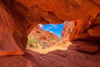
Ice Cream Canyon Trail explores a colorful canyon tinted with reds and greens. Various barrel cactuses and chollas dot the canyon walls.
This trail crosses beds of porous volcanic rock called “tuff.” Bighorn sheep sometimes roam the canyon’s narrow confines.
Walk the first 0.75 mile of Stamp Mill Trail, then fork right (south) onto Ice Cream Canyon Trail. The path traces the wash bank up-creek, then drops to the bottom of the wash. After 0.25 mile you’ll pass a junction with Railroad Canyon Trail.
Ice Cream Canyon Trail tours the tuff and winds among the ironwood trees. Above, canyon walls soar higher and higher.
One mile from the junction with Stamp Mill Trail, a minor obstacle, a 4-foot-high rock fall, must be climbed. Now the cliffs above the trail top 50 feet, with a backdrop of cliffs that tower 300 feet.
The canyon widens, narrows, then widens again into a peak-surrounded basin, chock-full of paloverde. A short walk across the basin leads to a junction with the Railroad Canyon Jeep Trail.
(BEGIN TEXT OF INFOBOX / INFOGRAPHIC)
Stamp Mill, Ice Cream Canyon Trails
Where: Picacho State Recreation Area.
Distance: From Park road to Stamp Mill Ruins is 2 miles round trip; through Ice Cream Canyon is 5 miles round trip.
Highlights: Little visited park on Arizona border.
Terrain: Volcanic slopes, shores of the Colorado River.
Degree of difficulty: Moderate.
For more information: Picacho State Recreation Area, c/o Salton Sea = State Recreation Area, tel.(760) 393-3052.
More to Read
Sign up for The Wild
We’ll help you find the best places to hike, bike and run, as well as the perfect silent spots for meditation and yoga.
You may occasionally receive promotional content from the Los Angeles Times.


