Caltrans Says Car-Pool Lane Projects to Start Around End of ’95
- Share via
Dear Street Smart:
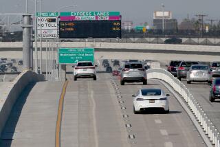
Many of us in Orange County travel to Los Angeles County on a regular basis. Recently, Caltrans has opened on the San Diego (405) Freeway in Long Beach a small addition to the car-pool lane system (about from Bellflower Boulevard to the Orange County line).
I think we’d like to know what the plans are for the opening of car-pool lanes on the San Diego Freeway in both the north and south directions, from the Orange County line to the Harbor (110)Freeway. Recently, car-pool lanes were opened on the San Diego Freeway from the Harbor Freeway to the new Glenn M. Anderson (105) Freeway.
Can you give us an indication of the car-pool lane implementation plans on the San Diego Freeway from Orange County through Long Beach and to the Harbor Freeway?
William Salmi
Huntington Beach
Caltrans has car-pool lane projects currently in design for two stretches of the San Diego Freeway, said Pat Reid, a Caltrans spokeswoman in Los Angeles. These stretches are from the Orange County line to the Long Beach (710) Freeway and from the Long Beach Freeway to the Harbor Freeway, she said.
Both of these car-pool lane projects are fully funded for construction, Reid said. It is expected that construction on these projects will begin around the end of 1995 and be completed in about two years.
Dear Street Smart:
I have long been confused by the conflict between the signs for northbound Ross Street approaching 17th Street and the traffic signals. The signs designate the two northbound lanes as turn lanes “ONLY,” left and right respectively; however, at the intersection there is a controlled left-turn light and a plain green light displayed.
The plain green light leads some drivers in the right lane to proceed north across 17th, an action that leads to citation by the Santa Ana police. It seems that the plain green light should be replaced by a controlled right-turn light similar to the prohibited crossing of 17th Street at northbound Flower Street a few blocks west of Ross Street.
Alan J. Nestlinger
Santa Ana
The City of Santa Ana begs to differ. City traffic engineer T.C. Sutaria says there are adequate signs instructing motorists to turn left or right and the traffic signals should not cause a conflict.
Besides the two roadside signs that instruct motorists to turn left or right, there are turn arrows painted on each lane of the roadway, Sutaria said. The overhead traffic signal is a plain green ball and not a turn arrow because it is guiding the pedestrians on northbound 17th Street who are allowed to cross on the east side of that intersection, he said.
Dear Street Smart:
Whittier Boulevard runs east and west through La Habra and is called California 72. The highway also turns south on Harbor Boulevard and continues south into Fullerton and Anaheim.
On Whittier Boulevard just half a block west of Harbor Boulevard on the north side of the street is a state highway sign that reads “south” and just below it is a state highway sign that reads “39.” This sign is not on California 39, it is on California 72, and the driver who reads this sign is actually traveling west, not south.
California 39 runs north and south through La Habra. It enters La Habra from the north on Hacienda Boulevard, then makes a long turn to the right (west) on Whittier and then turns left (south) onto Beach Boulevard.
This sign that I have mentioned is actually one and eight-tenths of a mile east of the intersection of Hacienda and Whittier. This sign is very misleading and should be removed.
James D. Harris
La Habra
According to the Caltrans State Highway Routes manual, California 72 begins at the junction of California 39 westbound to Downey Road near the Los Angeles City border. As you mentioned, California 72 is known locally as Whittier Boulevard.
In 1978, legislation was passed describing California 39’s jurisdiction as being “from California 1 near Huntington Beach to California 72 in La Habra via Beach Boulevard.” The portion of Whittier Boulevard eastbound to Harbor Boulevard (formerly California 72) in La Habra was adopted as part of California 39 in legislation that was passed in 1981.
Therefore, the sign reading “Highway 39, south” is correct even though it is still referred to as Whittier Boulevard, said Rose Orem, a Caltrans spokeswoman.
More to Read
Sign up for Essential California
The most important California stories and recommendations in your inbox every morning.
You may occasionally receive promotional content from the Los Angeles Times.


