Fanning the Flames
- Share via
Weather is the pivotal factor in setting Southern California’s hillsides ablaze. The intense heat generated by the flames creates its own weather, too. Here is a look at the dynamics of brush fire weather:
Firestorms
Resembling a tornado, a firestorm results when a brushfire becomes encircled by quickly rotating winds, such as an updraft in a steep-walled canyon. The winds swirl faster and faster, pulling in surrounding air and further fueling the fire. These massive blazes create their own wind patterns, which are strong enough to uproot trees and scatter embers thousands of yards away.
Fire-Generated Weather
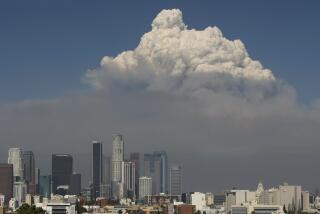
As the superheated, smoky air rises, it encounters cooler air and loses it heat. Moisture at higher altitudes condenses on particulate matter--smoke particles and ash--creating clouds. These convective clouds are characteristically flat, indicating strong upper-altitude winds. The phenomenon, which occurred Tuesday in parts of the Southland, is rare in this area but is common in the Rocky Mountains.
Santa Anas
Southern California’s notorious winds create perfect conditions for fire. The flow of hot, dry air originates far away in the Colorado Plateau and swirls southwestward, picking up speed and shedding humidity as it goes. As they pass through the canyons rimming the Los Angeles Basin, the winds grow even more intense, hotter and drier. Acting like a bellows, the hurricane-force gusts feed oxygen to the fire and spread it across freeways and canyons with devastating speed.
Sources: David Anderson, Interagency Fire Center, Boise; Dave Faires, U.S. Forest Service, Riverside Fire Laboratory; WeatherData; Peterson Field Guide.
Researched by NONA YATES and VICKY McCARGAR
More to Read
Sign up for Essential California
The most important California stories and recommendations in your inbox every morning.
You may occasionally receive promotional content from the Los Angeles Times.


