Flooding Lays Siege to Capital of Missouri
- Share via
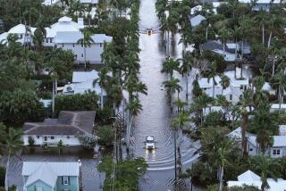
ST. LOUIS — Feasting on floodwaters, the Missouri River rose faster and higher on Friday than had been anticipated, its crest skimming the tops of the few levees still standing and quickening the pace toward a fateful rendezvous with the Mississippi River just north of this city of more than 400,000 people.
Moving up three feet in 24 hours, the Missouri and two feeder creeks transformed the state capital of Jefferson City into a near-island, cutting off access from the north, east and west.
The only three levees still holding between Kansas City and St. Louis huddle fewer than 30 miles from the Missouri’s mouth.
The rising river broke through a section of another levee in the area, the Monarch, forcing an evacuation of the Gumbo Flats, a 4,000-acre section of bottom land where the countryside starts giving way to light industry and offices.
Information on how much land had been flooded was not immediately available.
When this crest rolls south and joins the Mississippi near St. Louis, it will be the third to pass the city this month. It is now forecast to hit 49 feet on Monday, a foot higher and a day sooner than earlier predictions.
Work crews labored frantically to reinforce a weak section of the city’s flood wall, which is designed to hold back a river level of 52 feet.
Problems in the southern portion of the city continued as St. Louis police evacuated about 700 people from a neighborhood near a tank farm along the Mississippi River. The straps holding down 24 tanks, each containing 30,000 gallons of volatile propane, were loosened by rushing floodwaters. Authorities said they were worried that the tanks would break free and leak.
And even as several broken levees relieved pressure on the main channel of the Missouri, they also allowed debris to be sucked into the river. The debris can come together to act as miniature dams and there is so much now that it is affecting the river’s flow, said George Hanley, a spokesman for the U.S. Army Corps of Engineers in Kansas City.
The resulting high, swift water made for a day in which the river caught its namesake state by surprise--not the first shock administered to the Midwest in this summer of prodigious floods.
“We remain in a crisis situation,” said St. Louis Deputy Police Chief Raymond Lauer. “I think we got lulled into a false sense that everything is OK.”
On Thursday, the complacency ended.
Jefferson City
Missouri Gov. Mel Carnahan postponed a flood summit that had been scheduled for today. Despite the community’s central location, “you just can’t get into Jeff City,” Carnahan said, noting that portions of 300 roads and highways across the state are closed due to high water.
Indeed, the state has been virtually sliced in half. Just one bridge was open across a 200-mile stretch of the Missouri River.
The power supply to the state Capitol, which sits safely on a bluff, was threatened. Electricity was shut off temporarily on Thursday as workers scrambled to move transformers and other equipment to higher ground.
“The state Capitol building is kind of a symbol of the state, and we can’t let it be knocked out of power and admit defeat to this flood,” said Union Electric Co. spokesman Mike Cleary.
Carnahan urged all state employees who could to come to work. “It is important for state government to function,” he said. “We need to be here in a position to render service.”
But only about half of the 7,500 public workers were able to answer his call. Others live north of the river, and their main route across, U.S. Highway 54, was closed by high water.
The river was at 38.6 feet late in the day Friday, backing up a creek that usually meanders through downtown, engulfing dozens of homes and businesses.
“There’s nothing but an ocean of water,” said Theora Peterson, a Capitol tour guide who took a circuitous route to work. “The airport, the houses, the trees, the farmland--a lot of it is just gone.”
Tourists made it to town too, and they had lots of questions, interrupting Peterson’s usual spiel. “They’re usually asking about all the statues or about where the governor is,” she said. “Today is flood, flood, flood.”
The Levees
The Chesterfield, Riverport and Earth City levees were the last survivors along the Missouri on Friday.
But the Monarch levee near Chesterfield, Mo., started to become the focus for concern about 6 a.m., as the Missouri climbed higher and seeped under the barrier. St. Louis County moved 450 inmates from its minimum-to-medium security prison at Gumbo Flats to various jails in the region and to an indoor ice-skating rink, which was closed to the public.
More than 500 small planes took off from the county’s Spirit of St. Louis Airport in search of safer harbors. Many of the pilots had already transferred their craft once, from flooded airports elsewhere. A skeleton crew of air traffic controllers remained on duty; the rest were sandbagging their offices.
Water flowed across a road south of the airport that had been dry hours earlier.
The roads were clogged with rental trucks as about 250 small manufacturers moved their machinery out of the flats.
The Chesterfield levee, which protects a county water treatment plant, was reported in good shape.
And at Riverport and Earth City, two massive developments less than a decade old, fortress-like berms built to protect against a 500-year flood still held.
The $10-million Riverport levee, which took nine months to design and a year to build, guards an amphitheater where 20,000 people are expected for a flood benefit concert tonight, as well as a series of glass-and-granite-veneer office buildings.
When Sverdrup Civil Inc. had nearly finished the Riverport levee in 1986, the Missouri flooded. The 200-foot hole in the defenses let water 10 to 12 feet deep cover 500 acres.
Now the company is spending $200,000 to shore up its levee, even using ground radar and heat-sensing equipment to detect underground holes caused by seepage.
Iowa
Des Moines’ municipal water, knocked out for 12 days because of the flooding, was declared safe for drinking without boiling. Residents hadn’t been able to drink straight out of the tap since July 11.
Signs of the flood emergency were also being removed. Portable toilets were being carted away, and thousands of sandbags were hauled off as river levels dropped. Many restaurants were again serving food on real plates and bragging about their indoor facilities.
“Open! And Inspected!” boasted the advertisement outside one cafe.
Des Moines County Sheriff Joel Behne told the Associated Press that families were trickling back into the Dumbell Lake area just north of Davenport along the Mississippi, even though water levels were still high.
In Davenport, the President riverboat casino was cruising back to its home dock along the city’s riverfront after fleeing to Bettendorf, six miles upriver.
Said riverboat general manager Rob Long: “We’re delighted to be going home.”
Pasternak reported from Chesterfield, Mo., and St. Louis, and Lacey from Jefferson City. Times researcher Edith Stanley also contributed to this story from St. Louis.
RELATED STORY: D1
The Toll, State by State
State Deaths Estimated property damage Estimated crop loss Illinois 4 $930 million $565 million+ Iowa 5 $1.2 billion $1.6 billion Kansas 1 n/a $350 million Kentucky 0 $15 million* - Minnesota 4 $18 million $740 million+ Missouri 22 $2.7 billion* - Nebraska 2 $50 million $288 million N. Dakota 0 $53 million $353 million S. Dakota 3 $596 million $596 million Wisconsin 2 $101 million $800 million
n/a: not available * Property and crop damage estimates combined
More to Read
Sign up for Essential California
The most important California stories and recommendations in your inbox every morning.
You may occasionally receive promotional content from the Los Angeles Times.


