Spring Flowers : Burned Wilderness May Soon Blossom With Wildflowers
- Share via
From the seeds of destruction comes bold, new life, especially in Southern California’s chaparral belts. The Agua Tibia Wilderness, straddling the San Diego-Riverside County line east of Temecula, is a case in point.
In late July and early August, 1989, the 15,500-acre Vail Lake fire swept across the north-facing slopes of Palomar Mountain, charring some timber on the crest but mostly consuming vast stretches of tinder-dry chaparral on the lower slopes. Century-old stands of chaparral shrubs succumbed to sheets of flame.
The second blow of nature’s one-two punch came just three weeks ago, when a moist Pacific storm rolled in and delivered several inches of rainfall to those denuded slopes. It proved somewhat of a gully-washer for Agua Tibia, creating rock- and sand-filled mini-chasms in ravines where impenetrable thickets of brush once held the soil together. Dripping Springs Campground, just north of the wilderness boundary, was damaged by mudflows, and the Dripping Springs Trail, the main entry route into the wilderness area, sustained some damage as well.
Hidden in the desolate-looking landscape, however, are millions of seeds that have lain in wait for the right combination of moisture and sun. If we get another soaking rain or two and a liberal dose of warm sunshine, one of the best wildflower displays of the decade could occur here.
During my reconnaissance of the area two weeks ago, I noticed extensive stump sprouting of chamise and ribbonwood shrubs, tendrils of wild cucumber creeping across the ground, and patches of blooming purple nightshade, black sage, aster, wild pea, and wild hyacinth. Wild peony and red monkeyflower had yet to unfold their petals. Late this month and especially in April, carpets of annual wildflowers--perhaps lupine, owl’s clover, wild Canterbury bells, California poppies, and who knows what else--may appear. In May, the tide of blossoms should roll up the slopes, reaching the mile-high, upper elevations of the wilderness area.
Agua Tibia Wilderness, San Diego County’s first officially designated wilderness area, lies in Cleveland National Forest. To reach Agua Tibia, take Interstate 15 to Temecula and then drive east on Highway 79 for about 10 miles.
You must obtain a free wilderness permit before entering the area for either day-hiking or overnight backpacking.
Currently, permits can only be obtained from U.S. Forest Service offices, but starting April 1 they can be picked up near the trail head at Dripping Springs Campground. (This assumes that repairs to the campground, now under way, are finished in time for the campground’s expected April 1 opening date. Please contact the Palomar Ranger district, 1634 Black Canyon Road, Ramona, CA 92065, 788-0250, or the Cleveland National Forest supervisor’s office in the Federal Building, downtown San Diego, 232-3769, for the latest information.)
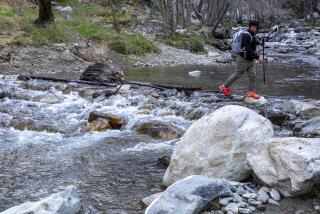
From the campground road (elevation 1,600 feet), pick up the Dripping Springs Trail, which immediately crosses the rocky bed of Arroyo Seco Creek and starts a gradual, zigzag ascent of slopes to the west. You can go as far as you like--6.8 miles to the summit ridge of Agua Tibia Mountain, or to any point short of that. You’ll return the same way.
The lowermost section of trail, which is the most damaged, will be the first to receive the attention of trail repair crews in April or May. After the first 1/4 mile, the trail is easy to follow as it makes a crooked ascent to the head of a small, dry creek at 3.5 miles (elevation 3,100 feet). Thereafter, it may be somewhat overgrown and a bit hard to follow.
At about 4 miles (elevation 3,300 feet), you’ll pass what little remains of the truly giant specimens of manzanita and ribbonwood that stood here until the 1989 fire. These century-old shrubs, up to 20 feet high, represented the equivalent of a “climax forest” consisting entirely of chaparral. The loss of this unique vegetation was tragic, but it must be remembered that without the effect of fire-suppression measures enacted over the past century, the natural cycle of growth and incineration by natural causes--roughly every decade--would probably never have allowed such a mature stand of chaparral to develop.
At about 4.8 miles (elevation 3,800 feet), the trail reaches a little crest, and a view opens toward the higher ridges of the Palomar Mountains, with the white dome of the Hale Telescope at Palomar Observatory gleaming in the southeast. From that vantage you may view the singed, but largely intact evergreen forest that crowns the Auga Tibia summit ridge, another 2 trail-miles ahead.
More to Read
Sign up for The Wild
We’ll help you find the best places to hike, bike and run, as well as the perfect silent spots for meditation and yoga.
You may occasionally receive promotional content from the Los Angeles Times.


