DOING IT THE NATURAL WAY : To Fully Appreciate Canadian Rockies, Take This Tip: Travel by Foot and Leave Your Car and Other Conveniences Behind
- Share via
BANFF NATIONAL PARK, Alberta — They’ve oversimplified the Canadian Rockies, according to the region’s venerable mountain men. Without remorse they’ve turned some of the world’s most rugged and remote landscape into a packaged vacation wonderland.
They’ve built towns with state-of-the-art conveniences, and codified the wilderness. Every trinket, knickknack and screened T-shirt with a Canadian Rockie emblem is being hawked along the congested main street in the Banff and Jasper town sites.
They’ve built a wide, gleaning asphalt thoroughfare--the Trans-Canada Highway--from Banff to Jasper National Park, six-hours of high-speed driving past the crags, crevices, valleys, peaks, icefields and accompanying wildlife endemic to the area.
Most visitors delight in this 100-kilometer-per-hour peek at Mother Nature while sitting in the comfort of their automobiles.
And thus, a goodly portion of the park, the most voluptuous vistas and palatial panoramas, remain unespied though some are less than a day’s hike away.
“It has become a Mecca for all the people who don’t belong in the park with the discos and T-shirt shops,” said Sid Marty, a former Banff park warden. “Some visitors don’t even care they are in a national park.
“But that’s the Bow Valley, which is godawful. Still, there’s another 2,300 square miles around it which are accessible only by trails. You can still leave the 20th Century behind.”
Brian Patton, co-author of “The Canadian Rockies Trail Guide” also has had his doubts about park management, but said: “We wouldn’t have had as much parkland set aside if stricter restrictions were placed on the park. Most of the mayhem takes place in the town sites.”
is celebrating its centennial year this summer. Its genesis is different than most parks because it was built around the Trans-Continental Railway, which runs through the middle of it.
“The railroad made the park possible,” Marty said.
Visitors first came via railway to visit the Cave and Basin Hot Springs near the town of Banff, Marty said. They didn’t consider the area anything particularly special considering most of Canada was a wilderness area in 1885. Since then, Banff and three adjoining national parks--Jasper, Kootenay and Yoho--have become one of Canada’s biggest tourist attractions.
Banff alone had 3.2 million visitors during the 1984-1985 season, according to Reg Joscelyn of the Alberta visitors center. But of those tourists, few hiked to the backcountry, he said.
The visitors’ service issued 5,000 overnight permits to about 15,200 hikers last season. By contrast, there were 382,000 visitors at the Cave and Basin Hot Springs near the Banff, a town of 4,500 people.
Joscelyn said the service has no way of estimating how many day hikers use the park, but park wardens say most tourists remain in their cars.
Marty, an author who lives on a ranch site near the Montana border, became disenchanted with what he calls Banff’s “inharmonious progress.” He said he reached an impasse with his superiors on the growth issue, and left the service in 1978.
But he still returns to the Rockies.
He still has an affinity with the mountains.
He still finds solitude on backcountry trails in such remote sections as the Icefield Parkway.
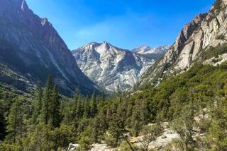
These mountains were made to walk, Marty and other mountaineers will tell you, and with a little investment of time the hinterlands can become friendly confines.
“Those who just drive miss what the park is all about,” said Perry Davis, a backcountry specialist in charge of Banff’s wilderness facilities. “There’s so much more to see in the backcountry and you have a chance to get away from the crowds.”
Patton says the Mount Assiniboine area, which lies along the Banff border in Mount Assiniboine Provincial Park in British Columbia, is becoming one of the most popular backcountry trips along with the Banff and the Lake Louise region.
Here’s a closer look at a few popular areas for the intrepid beginning hiker.
MOUNT ASSINIBIONE
Patton suggests hikers start at Sunshine Village, a vast downhill and cross-country ski resort just north of Banff. This is the first summer it has been open to hikers, Davis said. He said it is best to take the gondola to the village, which saves a rather tedious 3 1/2-mile ascent from the parking lot. Assiniboine, the Matterhorn of the Canadian Rockies, is about a 16 1/2-mile hike from the village, but backpackers need overnight use permits, available at warden offices, to camp there.
Those interested in day hiking will find the five-mile trek to Citadel Pass, which lies on the Great Divide between Alberta and British Columbia, to be rewarding.
“You’ll pass one of the most unique meadows in the Canadian Rockies because it’s right on the Divide,” Patton said. “It’s glaciated, eroded and rocky on the Divide. But there are a number of flowers that grow only in this area.”
The subalpine Sunshine region toward the Divide is fragile. Park wardens are undertaking continual restoration projects, and ask hikers to be especially careful when traversing there.
Said Davis: “When you’re up that high the growing season is only eight weeks. People walking off trails can do more damage than on their lawns.
“We’ve had cases where it looks like people were running dirt bikes over the landscape.”
Davis said backcountry trails can disappear in the alpine areas. Wardens say hikers should avoid following footpaths of others when the trail disappears. They say it is best to walk over rocky terrain or, if forced, to form a new trail.
The hike toward Citadel can be shortened to about seven miles round trip for the timid desiring a backcountry experience. Use Howard Douglas Lake as a turn-around point. It takes a somewhat strenuous ascent of a ridge below Quartz Hill, but the vista is worth the effort. On a clear day Mount Assinibione towers in the distance, and many wildlife such as ptarmigan, marmots and deer frequent the meadows.
Those going to Citadel Pass can continue to the barren Fatigue Pass, about a half-hour hike up the side of a rocky ridge, or descend into the Golden Valley and on to Lake Magog if they are planning to camp.
Mount Assinibione also can be reached from Canmore where a helicopter service flies visitors into the region. Patton said there are many four-mile hikes starting from Lake Magog at the base of Assiniboine, but it is difficult to reach on foot. He also said the area is crowded with the helicopters hovering overhead and mountain bicyclists using the route. Other suggested hikes: Sunshine Village to Simpson Pass (3.3 miles) and on to Egypt Lake (13.4 miles).
BANFF REGION
Patton and Davis recommend two hikes near the Banff town site--Johnson’s Canyon and Lake Minnewanka.
Davis likes Johnston’s Canyon because it is rustic, but easily attainable. The trail head is located at Johnston’s Canyon Lodge on Highway 1-A, the old road through Banff. A two-hour walk takes tourists to the Ink Pots, six clear green springs with a constant temperature of 35 degrees.
The hike to Lower Falls is extremely easy, Davis said, but increases in difficulty toward Upper Falls and the Ink Pots. The limestone walls rising above Johnston’s Creek dates to the Paleozoic and Mesozoic eras, Patton said. Ambitious day hikers can continue to the Hillside Meadows behind Mount Ishbel, but most return from the Ink Pots.
Lake Minnewanka, Banff’s largest lake, is a multiple-use trail for beginner to expert. The eight-hour trek to the Ghost Lakes is a serious hike; it is then another 14 miles to Carrot Creek Circuit.
Most, however, enjoy the level walk around the lake’s perimeter, Davis said. Minnewanka was turned into a reservoir during World War II when a power dam was built at its west end. It offers beautiful views of the Stewart Canyon and the Palliser range. The 16 1/2-mile Lake Minnewanka Trail takes between seven and 10 hours to complete, according to hiking guides. Other suggested hikes: The Discovery and Marsh Trails (for bird lovers), Stoney Squaw Mountain and Cascade Amphitheatre.
LAKE LOUISE
The famous emerald lake may be the park’s biggest attraction, but it also is the starting point of many a wonderful hike. Not surprisingly, the hikes originating from Lake Louise are some of the Rockies’ most popular. But they also are some of the most breathtaking.
Marty used to maintain the trails and the Swiss guide huts at Abbott Pass on the Great Divide between Lake O’Hara in Yoho and Louise. He said he used to hike once a week between the lakes, but such an endeavor is for the experienced.
“Once on the shoulder of Mt. Victoria I saw a Grizzly bear come by,” Marty said. “I don’t know how he got to the ridge in the first place because he had to cross a glacier to get there. But he just came along the one side and then slid down a snow slope the other side to Lake Oesa. He seemed like he knew what he was doing.”
An enriching day hike that requires some tricky logistics is the Lake Morraine to Lake Louise trail over Sentinel Pass. It is a rugged 16-mile trek that is most rewarding in late fall.
Hikers can save about five miles by parking at Lake Louise and getting a ride to Lake Morraine, which is the best place to start. From Morraine it is 1 1/2 miles of switch backs through a thick forest of Engelmann spruce and alpine fir to the Larch Valley. Behind Morraine is Valley of the Ten Peaks, which rise directly above Morraine. Davis said the Larch forests turn the valley into a brilliant golden hue of flora during late September, and attracts a week-long pilgrimage of hikers. Most day hikers stop at the valley and return.
A reporter on the trail in mid-August found a storm blowing a light shroud of snow through the valley offering a sereneness to the mountains. The storm, however, made crossing rocky Sentinel Pass hazardous. Sentinel (8,566 feet) is the highest of the park’s passes, and is doubly difficult to descend because the trail disappears on the backside. Hikers must bushwhack down the mountain (it took more than an hour in snow) to reach the base.
The eight miles from Sentinel to Louise are a real treat. The hiker first walks through aptly named Paradise Valley and then can take a short side trip to Giant Steps, an interesting cascade. The trail then traverses past Saddleback peak and on to Lake Louise. Other suggested hikes: The short, yet spectacular hike from Louise to the Plain-of-the-Six Glaciers and the teahouse viewpoint. Patton also suggested an undeveloped and difficult hike along the Great Divide from Banff to Lake Louise. The Great Divide Trail goes all the way to Mount Robson, the highest peak in the Canadian Rockies, to the north, and to Waterton International Peak Park on the U.S. border to the south.
The warden offices have detailed information on all hikes, which they encourage people to take.
“People are habitual travelers by car,” Davis said. “The park really is closed down to them. They don’t realize if they just stopped, stood still, a whole new world would be opened.”
More to Read
Sign up for The Wild
We’ll help you find the best places to hike, bike and run, as well as the perfect silent spots for meditation and yoga.
You may occasionally receive promotional content from the Los Angeles Times.


